


Before leaving Kaitaia I had to fill up the hire car with petrol. I had the good idea to work out how to open the tank while I was still at the hotel so I didn’t have to fumble at the petrol station. I was surprised when a nice girl came out to fill the tank for me. I headed east out of Kaitaia along SH10 towards Kerikeri. It was cloudy and there were a couple of rain showers as I drove. Fortunately the sun came out as I got to Kerikeri.
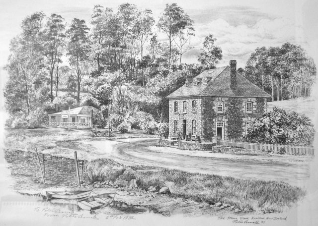
I wanted to see the stone store in the town as many years ago the family that I know in New Zealand had given me a print of the store. The artist had the same name as me and they had managed to get him to sign the print “From Peter Arnold to Peter Arnold”. The stone store was built by English missionaries in the mid-1830’s and is the oldest surviving stone building in New Zealand. As you come into the Kerikeri from the north there’s a well signposted car park. From there the road crosses a river. Halfway across the bridge gives a good view of the store stone, similar to the view in my print.
![]()
![]()
![]()
![]()
![]()
![]()
![]()
![]()
The print of the stone store from 1982
![]()
![]()
![]()
![]()
![]()
![]()
![]()
![]()
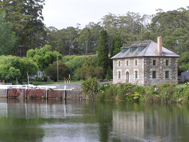
The trees have grown up a bit in the past 20 years
There’s a museum in the store but wasn’t open when I arrived so I wandered across to the Kororipo Pa, a Maori earthen fort. It was from here that the local chief gave permission for the missionaries to build their outpost. The pa is just a grassy hill now but from there you get another good view of the stone store. By the time I got back to the store the museum had opened. I found it a little disappointing, it didn’t take long to look around their collection and I felt that $7.50 (£2.80) was a bit steep compared to the cost of other things in New Zealand.
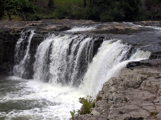
I drove through the centre of Kerikeri and headed south to the Waitangi. I stopped for a quick look at the Haruru Falls, a waterfall in a crescent shape. According to Maori legend a water monster lives behind the falls. There was an intrepid group of canoeists paddling around in the splashing water. They all survived; I guess the monster was asleep!
![]()
![]()
![]()
![]()
![]()
![]()
![]()
![]()
Haruru Falls – not much of a fall but it looks nice
Waitangi is the location of the original residence of the British governor and is where the treaty between the United Kingdom and the Maori tribes was signed. Although the UK had claimed New Zealand as its own it did not have enough manpower to control the area. With the French and even the United States navies sniffing around in 1840 the governor signed the Treaty of Waitangi with the Maori chiefs. This gave Britain sovereignty but the Maori retained rights to land, forests and fisheries.
The car park at the treaty museum is woefully small. In the end I left my car down near the river by a boat club. Fortunately it was still there when I came back. There’s a good short film about the treaty in the visitors centre then I walked around the grounds by myself instead of taking the guided tour.
![]()
![]()
![]()
![]()
![]()
![]()
![]()
![]()
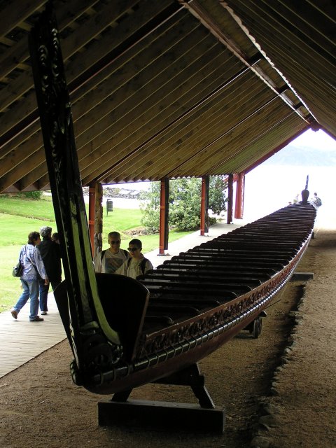
First stop was the canoe store. This 76-steater was built for the 1940 centenary celebrations from 3 kauri tree trunks
![]()
![]()
![]()
![]()
![]()
![]()
![]()
![]()
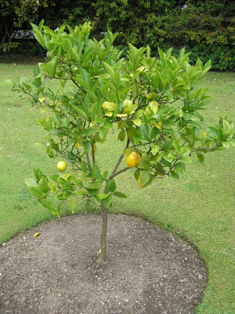
A lemon tree growing outside the treaty house. It shows the mild climate that northern New Zealand is known for
![]()
![]()
![]()
![]()
![]()
![]()
![]()
![]()
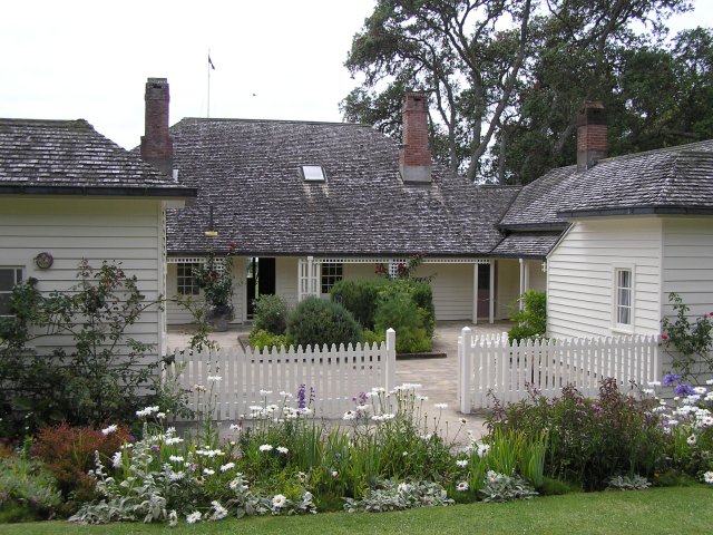
The Treaty House, the original governor’s house, greatly extended over the years from the original built in 1833. Its timbers were cut in Sydney and shipped across from Australia - an early pre-fab
![]()
![]()
![]()
![]()
![]()
![]()
![]()
![]()
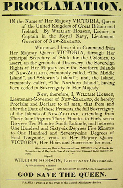
The proclamation issued by the Governor after the signing of the treaty
Once again, despite the poor start to the day it turned into a nice afternoon. Handy, as I had a boat cruise of the Bay of Islands booked! From Waitangi I drove the couple of miles south to Paihia, a small town on the coast of the Bay. Paihia was very busy and I was despairing of finding somewhere to park, especially as all of the free spaces were limited to 1 hour parking. Fortunately at the far south end of the beach I found an empty 4 hour bay which gave me just enough time for lunch and the boat trip. Over the road from where I parked was a nice little café where I had a salad and ice-cream.
I then wandered up to the town centre and the maritime centre where the boats depart from. Rather than a leisurely cruise I had opted for a 90 minute, 50 knot thrash around the Bay of Islands. We started with a safety briefing and we were all kitted out with waterproofs and lifejackets before we boarded the boat. I managed to get a seat near the bow so I had a good view forward. Travelling at 50 knots it was hard to take steady photographs but the captain often slowed the boat for us. It would probably have been hard to hear his commentary over the engine noise at full speed.
![]()
![]()
![]()
![]()
![]()
![]()
![]()
![]()
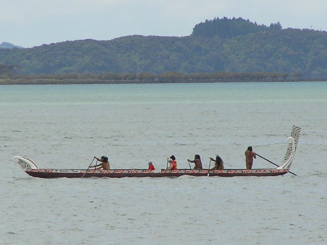
Whilst waiting for the tour to start this Maori canoe paddled past. My cruise of the Bay of Islands was to be much faster!
![]()
![]()
![]()
![]()
![]()
![]()
![]()
![]()
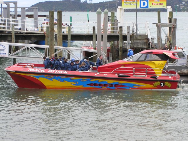
The fast cruise boat with the previous tour disembarking
The first stop on the cruise was to pick up more passengers in Russell across the Waikare Inlet from Paihia. Russell was the capital of New Zealand until it moved to Wellington in 1865.
![]()
![]()
![]()
![]()
![]()
![]()
![]()
![]()
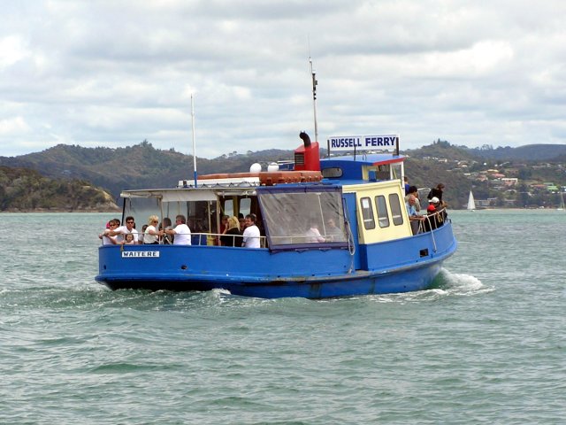
We zoomed past the Paihia-Russell ferry
![]()
![]()
![]()
![]()
![]()
![]()
![]()
![]()
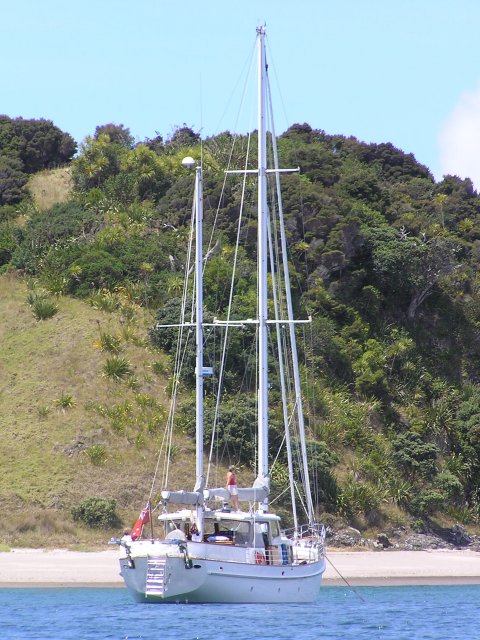
Further out were many yachts anchored off the numerous islands in the bay
![]()
![]()
![]()
![]()
![]()
![]()
![]()
![]()
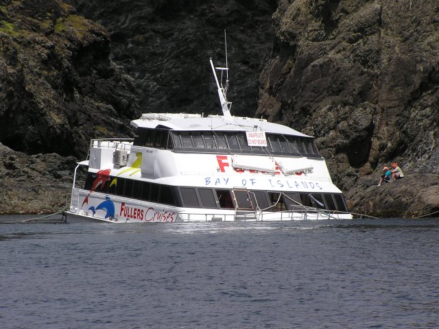
Our tour boat stopped at the tip of Cape Brett while the captain said something about the lighthouse at the top of the cliffs. We were all far more interested in this sunken boat. I later found out that its engines had failed and it had run aground, holeing the hull
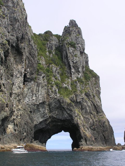
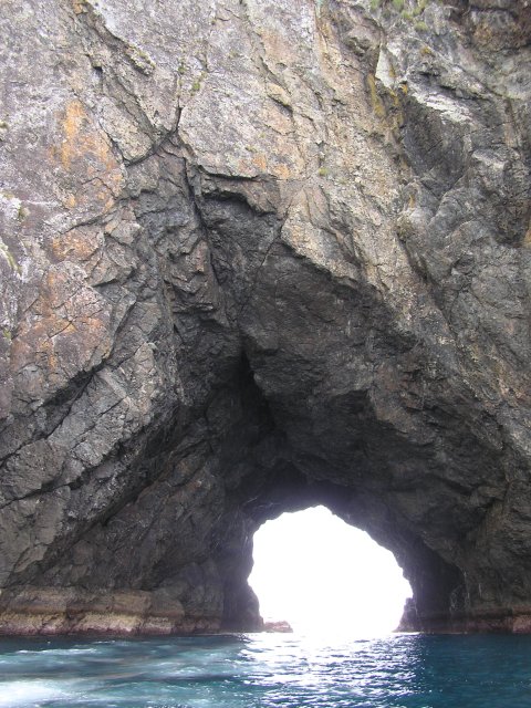
The highlight of most tours of the Bay of Islands is a trip through the “Hole in the Rock”. Wind and wave action has carved a large hole in an island off of Cape Brett at the eastern end of the Bay of Islands. When the wind and tide is right boats can travel right through the hole.
![]()
![]()
![]()
![]()
![]()
![]()
![]()
![]()
The hole in the rock from afar
![]()
![]()
![]()
![]()
![]()
![]()
![]()
![]()
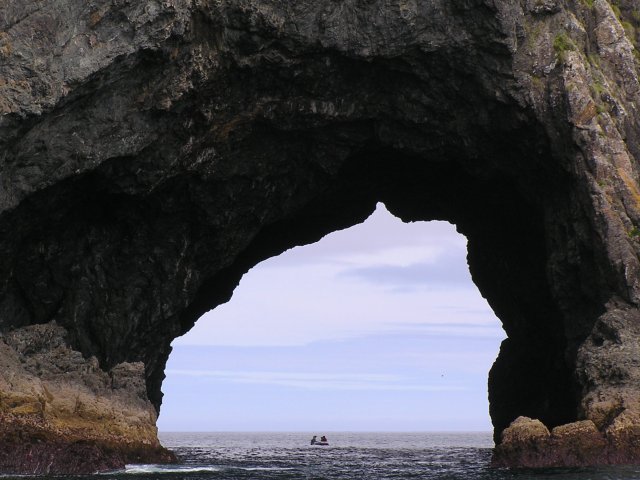
As we approached the hole a dinghy appeared from the other side, forcing us to wait as it chugged through
![]()
![]()
![]()
![]()
![]()
![]()
![]()
![]()
We went right through the hole but sailed round the island to get back to Paihia
From Paihia I drove south to Whangarei where the parents of my friend from Auckland lives. They had very kindly offered me dinner and bed for the night.